The history of urban design and spatial planning over the past forty years was largely reviewed from a macroscopic and aesthetic viewpoint rather than from a microscopic and physiological one. Re-analysing it from the microscopic perspective, we can discover the factors that did influence the formation of cities. A new evaluation proposed here will make it possible to create an alternative to the actual development of urban planning that is currently based on the principle of economic globalisation which is unsustainable and unfair to people. It is an ambition of our studio to contribute to the development of planetary urban planning to make it more acceptable, human, honest and fair to all.
Popularisation of the macroscopic and aesthetic urban analysis must undoubtedly be attributed to Italian architect Aldo Rossi who, in his book L’architettura della città (‘Architecture of the City’) of 1966, deprecates ‘naïve functionalism’ that reduces the history of the city and its design to the physiological and organic. From the very first page of the introduction he recognises the physiological cause as the origin of architecture. The starting point is the biological need that drives man to ‘construct an artificial climate’, more favourable for his existence. Evading this point, Rossi immediately claims that, first and foremost, man built his environment following aesthetic and civilisational intents. He studies those macrostructural intents, deriding all infrastructural approaches, which he considers naïve. With all due appreciation for Aldo Rossi’s achievements in the field of theory, and in a non-polemic spirit, we choose to side with the naive and to partly contest that macroscopic take, opting to reverse the angle of the analysis so that it starts from the microscopic level. If Aldo Rossi seemed so radical in 1970, it stemmed from the fact that since the 1950s antibiotics came into wide use in the West, a change which brutally invalidated the whole hygiene programme of architectural modernism and its physiological language. Critical of narrow streets and opting for zoning, in the Athens Charter Le Corbusier deals with bacteria hot spots, thus following the first 18th and 19th century hygienic regulations introduced by Rambuteau and de Horne1 , Maret and Soufflot2 : he is against stale air in dark narrow streets and badly ventilated rooms. The formal language of the modernist architecture of the 1920s – wide windows and glazed bays, balconies and solariums for the purpose of air and solar treatments, as well as white disinfectant lime slurry – are vivid declinations of the design patterns of Alpine sanatoriums, invented in the 19th century to combat tuberculosis and other bacterial diseases. This medicinal language loses legitimacy with the discovery of penicillin. What is the point of demolishing small, narrow and dark lanes or moving flats to spacious parks if it is now possible to eradicate disease with antibiotics, taken twice daily for one week? It should be pointed out, by the way, that modernist sunshine and fresh air were not particularly successful treatments.
What Aldo Rossi considered to be the first cause in the history of urban planning may have been in fact merely a consequence of the use of antibiotics: functionalism preceded aesthetics, physiology allowed symbolism, microscopic factors implied the macroscopic aspects. The reversal of the cause-and-effect chain, which we will propose to explain the history of the city and urban planning as resulting from the macroscopic and physiological considerations, is crucial to design the future. Partial success of Rossi’s postmodernism of 1970–1980 stems from the fact that it led to a construction of forms without causes, leaving merely effects of urban facts. It may be exemplified by a multitude of new squares with rich symbolism but without the physiological sense of the previous ones, when it had been necessary to fetch drinking water before social bonds were formed. We propose to study this particular reversal of the cause-and-effect relationships in urban planning and spatial design, and as a starting point we choose the achievements of new schools of thinking of history, geography and economy.
In his texts Guns, Germs, and Steel: The Fates of Human Societies of 1997 and Collapse of 2005, Jared Diamond described the above mentioned reversal of the cause-and-effect relationships, pointing out the importance of environmental factors: climate, geology or viruses in human history3. It was Spaniards who conquered South America, while Aztecs did not conquer Spain because the viruses carried by a bunch of conquistadors multiplied more easily and were more lethal than the viruses carried by millions of Aztecs4 . The history of America presented by Diamond appears to be much more a consequence of viral toxicity than a political or religious programme written in its course. In a similar way, the American scholar explains the rise and fall of the Viking civilisation or of the civilisation on Easter Island, justifying their development by climatic changes and soil erosion. Following the logic of this new school of thinking, some scholars have recently pointed out that the times of social change in the history of China correspond to periods of drought in the climate5 , while periods of great cold in the European Middle Ages are related to an increase in the importance of religion6. We might presume that, with advances of modernisation, the history of civilisation should become increasingly independent of the influence of the climate. However, in Climate Wars Harald Welzer describes the opposite tendency. He shows that natural disasters are behind the wars fought in the 20th and 21st centuries: to him, climate change is an underestimated social threat and it seems we are failing to accept the idea that this phenomenon, even if described scientifically, may generate such calamities as the implosion of social systems, civil wars or genocide7.
Economist Daniel Cohen believes the same, offering surprising reinterpretations of what seemed to be the cause while in fact was the effect8 . He explains the disappearance of social diversification in the modernist city not by the Athens Charter, which proposed to separate the working zones and housing districts, but by the invention of the lift, and then RER, the regional express transit system connecting suburbs to Paris. It was only yesterday that in a typically formed city the rich lived on the second floor, and the poor on the last one. The rich and the poor met on the stairs and even if they did not speak to each other, their children sometimes attended the same schools. Since lifts came into widespread use, buildings started to be inhabited by the rich or the poor but never by both because they lived in different districts. The district is decreasingly a place of social diversity’. As to RER, Cohen explains that it is not so much a means of transport that brings people from different social strata closer as an element contributing to their separation. ‘What is worse, with RER in use, suburbs tend to be increasingly isolated from luxury districts. In the past working class suburbs were not situated so far from city centres because workers had to walk to work on foot. With the opening of RER, the distance could grow. However demography develops, Paris will never border with Sarcelles. Suburbians go to the city centre on Saturday nights to feast their eyes on pictures but then return home’.
Endocrinological Land Development in the 19th Century
Rethinking the history of urbanisation from the microscopic perspective – endocrinological in the 19th century, and bacteriological in the 20th century – leads to unexpected re-evaluation of the process of city and cityscape making. Medicinal properties of iodine were recognized in the first half of the 19th century, and were popularised by English doctors who started to send their patients to the seaside or to thermal spas where iodine was administered either in the liquid form: soda or sea breeze, or in the solid one: fish or algae9. It resulted in the construction of a railway network and urban development of the sea coast. New spa towns were founded, such as Biarritz, Brighton, Spa, Ostend, Vichy, Arcachon or Évian-les-Bains. At the local level, urbanisation of Europe in the 19th century and the invention of tourism are the formal, planned consequences of the discovery of iodine and its medical applications. It was also instrumental in the formation of the image of European cities which since then turned towards beaches and waterfronts, sprawled and opened towards seas or lakes, those ‘veritable sanatoriums in the open air where the lucky sick come to enjoy the iodine-rich ocean air and pine fluids’10. For instance, in the 19th century the morphology of Swiss towns was totally reversed for that reason. Until the turn of the century buildings faced away from waterfronts and lake shores into which sewage was poured. Houses turned their backs at lakes and faced mountains. It was a total transformation. Ever since water becomes valuable because of iodine, new buildings – like those big residences in Montreux – turn towards lakes. The high street, which was once situated away from water, gets doubled with the construction of new boulevards designed for strolling along the waterfront. This is how European lake and sea shores, rehabilitated owing to iodine, become steadily urban. Some time later, around 1860, Louis Pasteur discovers that the air we breathe is not empty but contains bacteria, which are slightly less numerous in the mountains11. This medical knowledge, combined with what might be called the germicidal power of solar radiation in the treatment of tuberculosis12, entails impressive urban development of the Alps: Leysin, Davos and Gstaad are established. Written at the end of the 18th century, the diaries of Timoléon Guy François de Maugiron or Voyages dans les Alpes (‘Voyages in the Alps’) by Horace-Bénédict de Saussure imply that mountain areas were generally avoided as places of extreme poverty, inhabited by degenerate people13. The discovery of iodine, followed by the popularisation of solar treatments, sun bathing or heliotherapy14, recommended in Switzerland by Dr Bernhard or Dr Rollier, turn these places into favourite holiday destinations. Just like the theses proposed by Rossi in L’architettura della città stem from the discovery of penicillin, the theses put forward by Le Corbusier in Towards an Architecture or in the Athens Charter result from the discovery of iodine, the germicidal power of sunshine and the observation that the numbers of microbes decrease in less polluted air.
Thermodynamic Urban Planning in the 21st Century
Understanding the causal mechanisms is crucial, and a microscopic mechanism often enables to reverse their order: what seems to be the cause at the macroscopic level turns out to be a consequence in the microscopic perspective. If we want to define urban planning and territorial strategy towards the future, we need to analyse the real causes underlying land transformations. From the architectural and urban planning points of view, climatic and energetic parameters are closely related and seem to be the main factors that influence and will continue to influence urban renewal in a given area. The concept of ‘thermodynamic urban planning’, which I shall define presently, may encompass a whole set of criteria activated in the process of urban renewal on our planet.
The microscopic reason which will certainly underlie all major architectural and urban planning decisions in the 21st century is carbon dioxide (CO2). It is expected to play the key role; for two decades we have been trying to embrace the negative consequences of the growth of CO2 concentration in the atmosphere caused by non-renewable energy consumption, such as oil or gas. Fuel combustion releases CO2 into the atmosphere, which forms a sort of cover that makes it impossible for surplus energy accumulated over the earth to escape into the outer space. It results in global warming, disturbing the climate balance, on which urbanisation of the planet has been based for centuries, and causing disasters and migrations. Energy consumed by buildings (heating, ventilation, air conditioning or hot water production) is responsible for emitting about 50% greenhouse gases. Hence, architecture and urban planning are directly involved in an ecological and civic mission for the reduction of energy consumption. The discovery of the role of CO2 in global warming and the dissemination of that knowledge by the IPCC (Intergovernmental Panel on Climate Change) since 1988 certainly determines the end of postmodernism and invalidates reading and designing purely aesthetic and symbolic architecture. The necessity to deal with climate warming imposes new duties on architecture and urban planning, and confronting them is a matter of no less import that the confrontation with bacterial diseases was for modernism in the 19th century.
Following the Fukushima disaster (2011), a nuclear disaster was added to the climate crisis, forcing a process of steady abandonment of this kind of energy. Deprived of unlimited access to fossil fuels or nuclear energy, and unable to immediately replace them with renewable energy sources, such as the sun or wind, at the beginning of the 21st century we are urged to immediately reduce energy consumption. In this context, with view to the necessity to save it and use natural local energy sources, it is time to define the concept of thermodynamic urban planning; just as we are beginning to practise architecture called green, solar, ecological or meteorological.
Thermodynamic urban planning may prove to be a new way to come to terms with globalisation, through reorganization of industrial production at the planetary level based on energetic and climatic, rather than economic, criteria. We are currently at the peak of the postindustrial society crisis, which was based on global distribution of labour divided between the North, with highly qualified personnel developing ideas, programmes, design and marketing, and the South, with unskilled workforce manufacturing objects, computers or clothes. Until 1960 the South exported only raw materials for use in the North. Since the 1960s industrialisation of the South has entailed de-industrialisation of the North; since then the South has been exporting ready-made products, leaving the North to develop product concepts, design and marketing. This situation is risky because the technological advantage of the North over the South is decreasing on a yearly basis and it is predictable that production of ideas, design and concepts will soon reach the same level in the South as in the North, which will automatically reduce employment and increase unemployment, especially in Europe. How is Europe and France to be seen in this regard? What can France do, with its limited industry and extensive technological expertise (nuclear energy, TGV) which will soon become obsolete, in view of technologies developed in the United States, including Google and Facebook, if it neither develops nor manufactures its own products? There remains the production of luxury goods, cultural and culinary tourism so well described by Michel Houellebecq15 as the future of industrial France huddled around the ‘territorial magic’ of its countryside. Cheeses, cold meats, woodpigeons and snails, the Massif Central and a network of routes ‘Lodging and Castles’. Indeed, cynicism aside, some products belong to a given territory, which is inextricably related to a certain climate, quality of mineral soil that gives produce unique taste, just like lime soil and sunshine to the great wines of Bordeaux. It is not about skills or cultural traditions which globalisation will certainly copy, hybridise and delocalise but certain geographical, geological and climatic conditions that are unique and characteristic for a place: as Houellebecq has it, it is a regional category rather than a state one. Although it is impossible to transfer wine production from Bordeaux to China or Bangladesh, it will not hinder the establishment of new territories like Napa Valley in California or Ningxia in China whose wines were classified as the best in the world in 2011.
To explain the concept of thermodynamic urban planning, we can start from three examples illustrating a characteristic mode of exploitation of unique energy resources typical for a given geographic location. The first example is the transferring of Facebook servers from California to Lulea in Sweden. Computers storing a gigantic amount of information overheat, and cooling them requires a tremendous amount of energy. The average annual temperature in Lulea is 2 degrees Celsius, and it is easy to understand what savings (in tens of billions of dollars) the American company can make by moving the servers from the Mediterranean climate of California, where the average annual temperature is 19.5 degrees Celsius.
The second example is the Swiss village of Trient. The small village, with a population of 150 residents, hidden in the rugged mountains of the canton of Valais, without a ski lift, will receive several million Swiss francs in the next few years because it has a glacier that supplies water to a dam which provides electricity to the whole Swiss railway.
The third example is the German project Desertec, under which it is proposed to cover the whole of Sahara with solar panels to supply electric energy to the whole of North Africa and Europe16.
These three examples point at new, unusual, almost uninhabited urbanisation areas such as the north, deserts and high mountains. They have nothing in common with the places that have undergone urbanisation since the beginnings of humankind. In the 21st century we will witness a radical modification of the criteria of geographic value; we will see a change of human geography which will entail the establishment of new cities and a collapse of old ones.
Thus, climate will have a key role in future urbanisation of the planet, following the global thermodynamic values related to the location parameters, with regard to latitude and altitude. It may turn out to be a solution fostering globalisation based not on unjust salaries or a specific international distribution of labour but on ecological and climate criteria applied on the scale of global population.
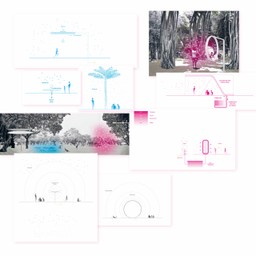
Thermodynamic park
We have applied global thermodynamic principles on a microscale in a city park in Taiwan: we created climatic differences as if we were to reorganise the planet’s geography reduced to the size of the park. The structuring principle is differentiation of climatic environments: from naturally existing warm, humid and polluted ones to newly created cooler, less humid and less polluted areas. Departing from what already exists, we defined three climatic maps, each of them typical for a given parameter of the atmosphere: the first one describing temperature, the second one referring to air humidity, and the last one describing the level of air pollution. Each of these maps contains modulations of respective parameters: from areas with extreme climatic conditions to those with deeper modifications and thus more suitable for human habitation. These three maps cross each other, freely overlap and thus create diverse microclimates, a multitude of various environments within the park’s space. One part will always be warmer but less humid, with less polluted air, while other parts will be cooler, drier but will have polluted air. The three climatic maps are based on the gradation principle: from 100% inconvenient, naturally intense conditions – typical for a local city (100% pollution, 100% humidity, 100% heat), to more pleasant zones with levels reduced even to 20%, where temperature, humidity and pollution were reduced to a minimum. To work out these three meteorological maps, we developed an extensive system of devices each of which reduces excess heat, humidity or pollution. What I call ‘meteorological devices’ are both plants, trees with specific qualities that absorb pollution or reduce insolation through dense foliage and waterspouts, humidifiers, fountains or technical solutions such as air dehumidifiers or mosquito repelling ultrasonic speakers. If we want to create a cool place, we increase the number of appropriate devices. Depending on their density in a given area, we create more or less pleasant and convenient spaces where climatic conditions sometimes overlap, combine, condense or, conversely, separate and dilute, generating diverse atmospheres which users can freely choose at will. Climatic devices are contemporary extensions of traditional park facilities: small constructions, such as benches, fountains, kiosks, garden pavilions or gazebos. Each of the devices reduces inconvenience caused by climatic factors at work and diffuses a more favourable climate, influencing one parameter only. The first are air dehumidifiers, followed by purifying devices, the third ones are air refreshing, light diff using and shade creating devices. If we want to achieve a low level of humidity in a given spot in the park and create a drier place, we simply place more air dehumidifiers there.
Meteorological devices and the type of soil which determines them are the basic elements of our composition, scattered over the landscape in the form of various levels of concentration depending on the intended level of efficiency. They enable modulation of the landscape texture and are unique to our architecture.
The distribution of programmes – public utility buildings, recreational areas, passages or playgrounds – takes place in a natural way, depending on the intensity of the new climatic zones. In the least convenient places there are closed air-conditioned buildings. Recreational areas are situated in the most favourable climatic zones, where the humidity levels and temperature are the lowest, and the pollution is minimal.
Translation from french: Aleksandra Wojda
English translation: Anna Mirosławska-Olszewska
Taichung Gateway Park
Authors: Philippe Rahm Architectes, Mosbach Paysagistes, Ricky Liu & Associates
Investor: Taichung City Government
Location: Taichung, Tajwan
Total area: 70 hectares
Design: January 2012 – December 2012
Completion: January 2013 – July 2015
Aleksandra Wojda